Built by surveyors to make your job easy
Civillo has been developed by surveyors, so we know it works.
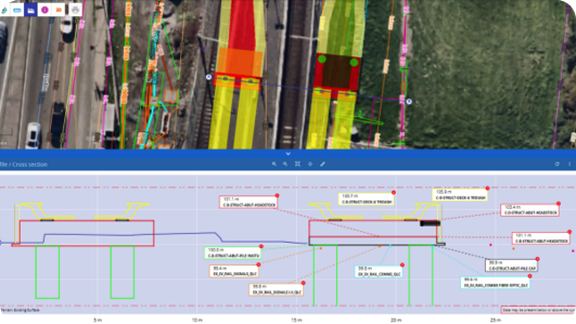
Eliminate 80% of your office tasks by making your data available on Civillo.
Enable your engineers and focus on what you do best
You've got three different work crews screaming at you for set-out, but you're stuck in the office pumping out cross-sections for an engineer who needs it done yesterday.
Sound familiar?
Imagine if you could simply upload all your survey data and design models to a platform where the engineering team can do the majority of the plans themselves.
With Civillo, you can.
Your expertise is most valuable on tasks that require a high degree of precision and accuracy. Give others the tools to work with spatial data and spend more time doing meaningful survey.
Fast-track communication
We've all experienced showing up to a project site for the first time, feeling completely overwhelmed by a new environment. All of a sudden the site supervisor is reeling off a list of things they need you to do, but you have no idea where anything is, or even where your control points are located.
Instead of madly scrambling with your head over your controller, praying that no one will come and ask you what the hold up is, open Civillo and get a fast, clear picture of the site, with easy access to designs, survey points, and imagery.
Even better - look at Civillo with the supervisor and be on the same page with where you need to go and what you need to do.
Use tools like Work Orders and Markups to further streamline communication between the office and field.